Finally got down to Gerroa to visit the site of a tornado that ploughed through the coastal forest on Seven Mile Beach in February this year. It was one of several that touched down then. One smashed its way through suburban Kiama, wrecking many homes. I know this coast very well and nothing similar has occurred in my lifetime, or in the folk memory of the region.
I wanted to see for myself because there was debate at the time whether it was a massive wind or an actual tornado.
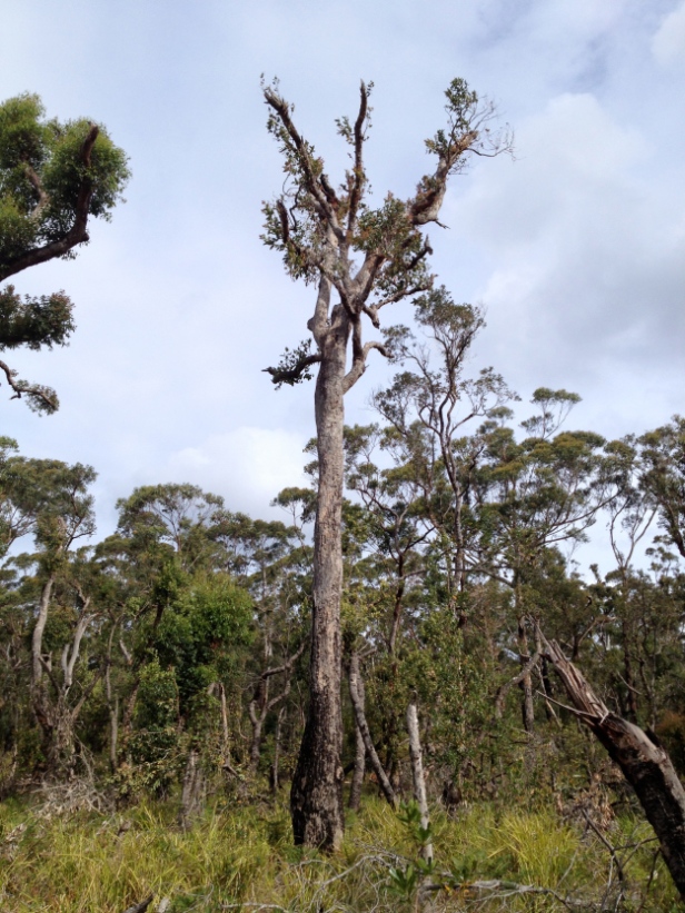
The first thing that surprised me was the width of the path of destruction, around 200 metres. Within this zone every tree under around 500mm diameter, mostly Eucalypts (Southern Mahoganies and Blackbutts – which are impressive trees) were snapped off near the base or pulled out of the ground. In the middle of the site was a large grove of Casuarinas around 200-300mm diameter. Every one was laid flat, mostly ripped out of the ground with their roots exposed.
The interesting thing is that virtually every tree was laid down at right angles to the path of destruction, left to right, consistent with a clockwise twisting force – which is the usual direction of tornados in the southern hemisphere (the Coriolis effect). The parallel rows of flattened trunks made it look like a scene from the Tunguska event. So I would say it was definitely a tornado.
In these photos the big Eucalypts still standing were stripped of all but their largest branches. (The foliage visible is regrowth since the event.)
Judging from pictures of smashed housing, the tornado that struck suburban Kiama at the same time must have been much smaller and weaker. The path of destruction there was much narrower, only one or two houses wide, and the wind, though enough to remove roofs and smash walls, had nothing like the fantastic force required to snap fully grown Eucalyptus trees.


Les
This is amazing I had no idea – when did it happen ?
Deb W
Hi Debs, Lovely to hear from you. The event was in Feb 2013. I hope you’re all hale and hearty up there. – Les